
Vous souhaitez contribuer à cette communauté et partager vos connaissances, vos travaux avec les lecteurs du PNRS ? Que vous soyez universitaires, étudiants, sapeurs-pompiers professionnels ou volontaires, agents administratifs, techniques ou spécialisés, venez participer à la démarche de mutualisation des connaissances et compétences et envoyez-nous vos contributions.
▼ Lire la suite
Votre avis en tant qu'utilisateurs nous sont très précieux : ils nous aident à adapter notre site et nos services en fonction de vos attentes.
Accéder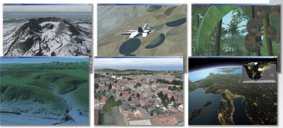
vieWTerra Evolution is a joint "GIS & Simulation" 4D Earth Viewer platform which can be used as very cognitive and immersive combined 3D/2D visualization tool in support of any potential crisis and relief operations on Earth (fires, floods, earthquakes, landslides, tsunamis, droughts, epidemics etc).
It allows integration and fusion of multiple combined Earth Observation (satellite), aerial/drone (Imagery, 3D models) or ground-based assets (photos, videos) and other type of information/data (Ecosystems, weather data, geo-information, metadata, forecasts, patterns, etc ), and their evolution and recording through Time (4D dynamic system). It therefore allows Crisis responders to rapidly build a virtual representation of one or several geographic location(s) on Earth within the general Globe environement, and offers scenario building capabilities to simulate events at their real-world location in the Preparedness phase, brings enhanced situational awareness in support of the conduct of operations in the Response phase and assists in the landscape planning, decision-support and communication operations in the Mitigation and Recovery phases. https://www.youtube.com/watch?v=ynbHOyBGQ0E vieWTerra Evolution has already been purchased to serve as Multi-hazard and risk platform by JICA-funded Disaster Preparedness and Prevention Center and in the Defense domain for use notably on C4ISR systems. It has recently been tested in trials performed by the DRIVER+ (Driver Innovation in Crisis Management for European Resilience) EU research project, notably alongside the IRONORE exercise within a major earthquake and chemical leak scenario and with a focus on the management of civil volunteers (Trial Austria ) ; and within the Final Demo of the project, which was targeting the communication needs of the different UCPM components (ERCC, EUCPT and Modules) notably in building a common operational picture and allowing exchange of information between several solutions, within a cross-border wildfires scenario.
For more info:
https://www.youtube.com/watch?v=ckc42RA9szo&feature=emb_logo
https://www.youtube.com/watch?v=XFq2uyXDrIM&feature=emb_logo
Description of the solution: vieWTerra Evolution, vieWTerra Mobile and vieWTerra Base form a combined “GIS & Simulation” suite of products allowing responders to rapidly build a virtual 4D representation (3D synthetic environment+ Time dimension) of any potential Crisis area on Earth, available both on desktop PC (off-line/on-line product) and mobile devices (Web browser application for PC, tablets and smartphones). These solutions provide a Common Operational Picture to both the Command Center and the rescue units out in the field.
vieWTerra Evolution is a 4D Earth Viewer as well as a data & assets integration and development platform. It can be used to model any type of 3D scene on Earth and create scenarios at their real-world location to simulate events in the Crisis phase, and serve as global repository for building a custom Earth-wide GIS, either used perfectly off-line (on PC, laptops or Windows tablets, using cache for possible use out-in-the-field also), or ported on an on-line architecture (Internet or Intranet private server), in order to allow the sharing of information and assets between multiple stakeholders in the Crisis Response phase. Exchange of information can be conducted both ways, either to and from the field notably allowing photos taken on-site, using commonly-used smartphones/tablets, to be shared with the Command Center.
vieWTerra Evolution presents an ellipsoidal model of the Earth defined at a certain level of resolution (vieWTerra Base global 29m Imagery, 90m DEM (upcoming 2021: 29m), 29m Land Cover database) and allows its users to integrate accurate Imagery, DEM and Land Cover datasets up to 45cm resolution anywhere on the Globe, without any area coverage limitations. Alternatively can be used also to access any Open Geospatial Consortium standard WMS/WMTS 2D data streams, displayed as additional layers over the vieWTerra virtual Globe, such as Open Street Map cartography, Copernicus web services 2,5m Imagery or Copernicus Emergency Management Service assets such as EFFIS fire forecasts, etc.
Offers management and recording of events through Time (4D system) : continuous time of day (real-time shadows and lights, replay of scenario or exercise, triggering of events). Also offers a dynamic weather system to easily create and simulate any type of weather (wind, rain, mist, snow, storms), which could be tied to current day/near real-time weather data feed.
Provides easy-to-use drag-and-drop functionalities for adding one's own data, information and assets from multiple sources (3D objects/ buildings, metadata, dynamic and user-controllable entities such as rescue units across all domains (e.g. helicopters, drones, trucks, ground units etc), which can be used either to create scenarios or represent movements of live assets/location of first responders at any time-using communication protocols; shapefiles or 2D drapes defining e.g. heatmaps, disaster maps, spreading models, tactical situation icons...; photogrammetry or LiDAR-acquired 3D terrain or objects models; custom labels, information or instructions under PDF form, on-site taken photos, videos or audio recordings…), all within the same software.
-> vieWTerra Evolution also offers real-time orthorectification and draping of newly-acquired Imagery from satellite or drone acquisition as state-of-the-art prototype module for rapid mapping and updating of the terrain database.
-> vieWTerra Mobile complementary application allows the display of the same data and assets database in a mobile, Internet or Intranet- based HTML5 Viewer application (cross-platform: PC/Mac, tablet, smartphones).
Gaps :
- Limitations in the ability to model large areas (Preparedness phase) and provide instant mapping ( Response phase)
- Interoperability issues: notably by incorporating disparate data sources and allowing data sharing between multiple stakeholders, since all datasets are merged in a single « One World » environment and encapsulated a single database
- Lack of Common Operational Picture: brings 3D rendering (very cognitive and interactive real-world like environment) in support of the conduct of operations both to decision-makers and commanders in the Command Center and to response units out in-the-field
TRL of the solution: 7/8 - System/Subsystem development
Expected/scheduled future developments :
- Worldwide DEM database: completion of global coverage at 29m
- Enhanced Augmented 3D capabilities (inverted Virtual Reality)
- Completion of capability to integrate on-the-fly acquired Imagery data (orthorectification) allowing permanent update of the global database with newly acquired datasets
- Land Cover/Ecosystems accuracy and 3D vegetation representation improvement (integration of more varied species and accurate placement)
- Buildings footprints and representation improvement
- Potential capability to integrate on-the-fly acquired DEM data (3D terrain models)
- Potential integration of local/global surface/soil/rock and subsurface data
- Integration of dynamic of the fluids calculations, validation of Proof-of-concept global water level rise simulation
Fichiers associés :
Lien associé : Web site vieWTerra Suite

 Retour