

Vous souhaitez contribuer à cette communauté et partager vos connaissances, vos travaux avec les lecteurs du PNRS ? Que vous soyez universitaires, étudiants, sapeurs-pompiers professionnels ou volontaires, agents administratifs, techniques ou spécialisés, venez participer à la démarche de mutualisation des connaissances et compétences et envoyez-nous vos contributions.
▼ Lire la suite
Votre avis en tant qu'utilisateurs nous sont très précieux : ils nous aident à adapter notre site et nos services en fonction de vos attentes.
Accéder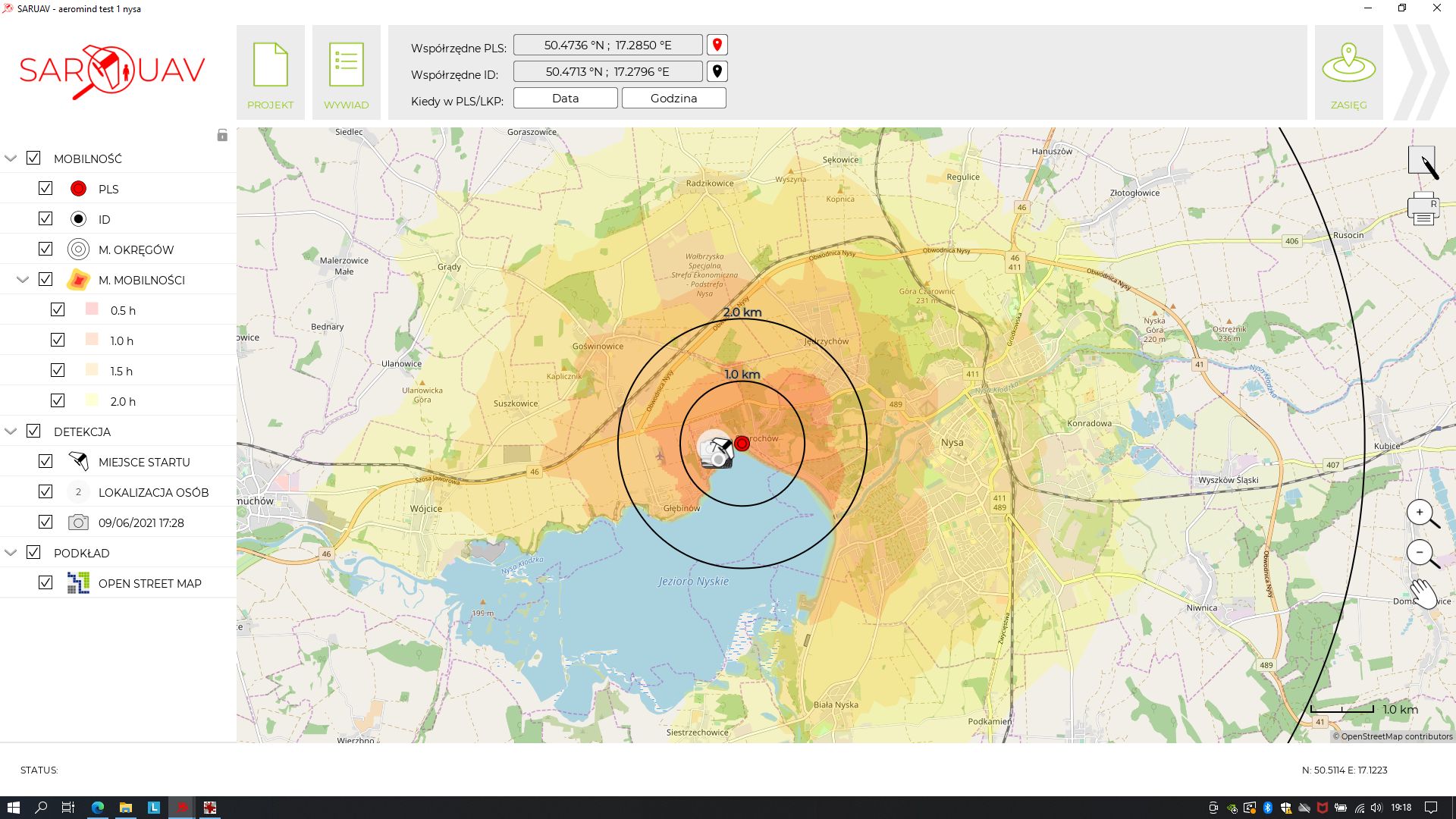
General description: The software was developed by a small polish company: SARUAV sp. z o.o. The head of the project is prof. Tomasz Niedzielski (tomasz.niedzielski@saruav.pl) It's a university project spinoff that has been developed in cooperation with a number of active SAR/firefighting units in Poland (for example OPS JRG Jarogniewice, GOPR Grupa Jurajska, OSP JRS SAR Głogów and others). It is fully implemented and tested. SARUAV is currently commercially available and in use by several Search and Rescue (SAR) units in Poland. The software drastically increases the efficacy of using drones equipped with visible light cameras in SAR operations. It is compatible across many (26 at this time) platforms.
Description of the solution: The software has 3 main functions:
1) missing person mobility simulation: based on initial information (time and location of Point Last Seen, Intended Destination, Travel Time, local SAR statistics) the program calculates how far a person could have travelled by foot in a given terrain and in a given time. Difficult terrain or uphill/downhill direction of the missing person are all considered in the calculation automatically. The product of this module is a mobility map, which can be easily shared with other responders in a universal format: HTML. The mobility map can be then used to plan further action, especially search flights of UAVs.
2) UAV should perform a survey flight (autonomous flight plan based on survey pattern), photographing the area with the camera directed downwards, with front overlap of each photo pair at 80%, and side overlap at 60%, and Ground Sample Distance at 1.5-3cm. This kind of flight can be programmed easily on most commercial drone platforms (for example Yuneec H520E, Autel Evo II series, DJI Phantom 4 series, DJI Matrice series). At the moment, there are 26 compatible UAVs (and their respective cameras). When the drone returns from the flight for battery exchange, we download the full resolution photos to a computer and send the drone out for the next flight. In the meantime, the SARUAV software will analyze the photos to quickly and accurately find any object resembling a person (or a visible part of a person) in the photos. The person operating the software then checks every detection (every detected person in the photos) to verify if the photo indeed may be showing the missing person. Each person detection is shown on the map, and the person location is calculated precisely. This is many times more efficient than trying to find the person by the drone/camera operator using only his eyes and the live video feed. The detections can be exported in a “.html” report file and sent out to ground teams.
3) SAR Mission planning and coordination - apart from the mobility simulation map, we can use the map in the software to draw points lines and sectors, we can also import GPX files from handheld GPS devices to view a rescuer's path. Visibility of these objects on the map can be turned on and off, as desired. All of this can be used to divide the search area into sectors, and to plan the whole SAR effort.
The developer made it so that adding more compatible cameras is fast and easy. To add a new camera, perform a short flight in accordance with the parameters above, write down the altitude of the flight and the start point location; then send the materials to the developer. The new camera will be added by the developer in a few working days.
TRL of the solution: 9 - System Test, Launch & Operations
Expected/scheduled future developments: The list of compatible cameras/UAVs is constantly expanding, and the detection algorithms are being refined all the time as well.
.
Lien associé : Web address

 Retour