

Vous souhaitez contribuer à cette communauté et partager vos connaissances, vos travaux avec les lecteurs du PNRS ? Que vous soyez universitaires, étudiants, sapeurs-pompiers professionnels ou volontaires, agents administratifs, techniques ou spécialisés, venez participer à la démarche de mutualisation des connaissances et compétences et envoyez-nous vos contributions.
▼ Lire la suite
Votre avis en tant qu'utilisateurs nous sont très précieux : ils nous aident à adapter notre site et nos services en fonction de vos attentes.
Accéder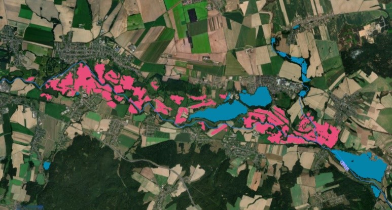
The scientists of the Joint Research Centre (JCR) have developed a new tool to estimate flood water depth and improve the accuracy of flood maps, the FLEXTH: “Flood extent enhancement and water depth estimation tool”.
By improving the accuracy of flood maps and providing information on flood water depth, this tool helps to better understand the extent of floods and facilitates relief operations. By collaborating with the CEMS and other services, the JCR is actively involved in reducing the impact of floods globally, providing a critical tool for protecting people and infrastructure.
Link : Europe floods: new tool to estimate water depth and extent - European Commission
______________________________
Les scientifiques du Centre Commun de Recherche (JCR) ont mis au point un nouvel outil pour estimer la profondeur des eaux de crue et améliorer la précision des cartes des inondations, qu’est le FLEXTH : « Flood extent enhancement and water depth estimation tool »
En améliorant la précision des cartes d’inondations et en fournissant des informations sur la profondeur des eaux de crue, cet outil contribue à mieux comprendre l'ampleur des inondations et à faciliter les opérations de secours. En collaborant avec le CEMS et d'autres services, le JCR participe activement à la réduction des conséquences des inondations à l’échelle mondiale, offrant ainsi un outil essentiel pour la protection des populations et des infrastructures.
Lien : L’article est en anglais mais peut être directement traduit en français sur le site : Europe floods: new tool to estimate water depth and extent - European Commission
.

 Retour